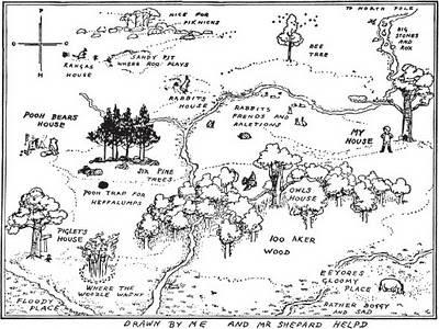
When I was a kid, I loved books that had maps. For instance: A. A. Milne’s “Winnie-the-Pooh” (above). And Arthur Ransome’s “Swallows and Amazons:”

I loved being able to follow along with the characters; to know exactly where they were as they went about their adventures.
Those books inspired me to draw maps of my own. I spent a lot of time designing imaginary worlds; countries jam-packed with hidden tunnels and valleys. Mountains and caves were essential too. Secret getaway places. Strongholds. Forts.
I never lost my love of maps. So when I wrote my novel Ultra, of course I needed a map!

That’s a map of Hither Lake; the body of water Quinn circumnavigates in his 100-mile race. You might notice that the shape of the lake bears an uncanny resemblance to the lake where I spent a lot of summers as a kid:


I loved those maps too! One of my favourite books was a picture map on each page and each map was a maze as well. You had to get the character from one place to the other. I can’t remember now what it was called…in fact I had forgotten it until I read this post! Now as an adult I spend too much time studying maps figuring out my next running route 🙂